Spexi Revolutionizes Drone Mapping: Powering XR and Digital Twins with 'Data Engine'!
As digital twins and Extended Reality (XR) increasingly become tech focal points, a core question remains before us: how to efficiently and precisely obtain the digital foundation of the real world? Canadian company Spexi provides a stunning answer. They're using cutting-edge drone mapping technology to provide high-precision geospatial data for these future technologies at incredible speeds, even delivering high-resolution imagery of millions of acres within 24 hours—undoubtedly a major breakthrough in the industry.
The Foundation of the Digital World
Imagine a virtual Earth precisely synchronized with the real world, or XR experiences that let you feel future buildings firsthand. These exciting scenarios all require massive, precise geospatial data as support. Traditional data acquisition methods are often time-consuming and labor-intensive, struggling to meet the rapidly iterating digital world's demands. At this moment, Spexi's innovative technology emerged, not only improving efficiency but opening a new chapter for digital twin and XR applications.
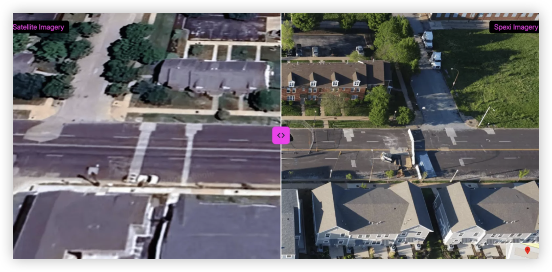
Deep Dive into "Orthomosaic Imagery"
To understand Spexi's value, we must first discuss "Orthomosaic Imagery." This isn't simple satellite photos—it's aerial imagery that has undergone geometric correction and stitching processing. This means every pixel in the image represents real coordinates on the ground, eliminating distortions caused by terrain variations. In mapping, planning, and even precision strikes, this geometric accuracy is crucial. Spexi's strength lies in their ability to generate such high-precision images on a large scale and quickly.
Spexi's Technical Highlights: Perfect Fusion of Speed and Precision
Spexi's technical core is the clever combination of geospatial data with drone operation networks. They've overcome many limitations of traditional aerial mapping, achieving a leap in "larger scope, higher speed, maintaining resolution." This means whether it's vast farmland, complex urban areas, or remote natural landscapes, Spexi can rapidly complete data collection through their distributed drone system.
This technology isn't limited to generating flat images—it also supports 3D point cloud and Gaussian Splatting model generation. This means Spexi provides not just 2D maps, but 3D, interactive real-world models—undoubtedly the foundation digital twins and XR applications dream of. More astonishingly, these high-precision data can be provided on-demand with 24-hour delivery promises, completely overturning traditional mapping's weeks or even months-long work cycles.
Multi-Domain Application Prospects: From Urban Management to Insurance Claims
Spexi's technological breakthrough will have profound impacts on multiple industries:
-
Government and Municipal: Urban planning is no longer just on paper. Through real-time updated digital twin cities, governments can more efficiently conduct capital planning, asset management, and even quickly assess damage and develop response plans during disasters. Permit approvals can also be based on precise geographic data.
-
Insurance Industry: Imagine post-disaster claims no longer requiring lengthy manual inspections. Spexi's timestamped high-resolution images help insurance companies quickly assess losses, effectively prevent fraud, and accelerate claims processes.
-
Construction and Engineering: Remote monitoring of construction progress, precise measurement of earthwork volumes, and reducing construction errors will all become reality. The combination of digital twin technology and Spexi data makes construction project management unprecedentedly efficient.
-
Spatial Computing and 3D Modeling: For developers committed to building metaverse and VR/AR applications, Spexi provides the best path to obtain real-world foundational data, greatly accelerating high-precision 3D content creation.
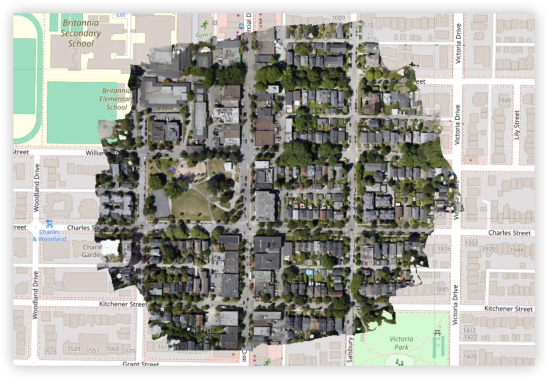
Spexi's Innovation Model: Victory of Distributed Networks
Spexi's success also benefits from its unique "distributed drone operation network" model. This forms a sharp contrast with traditional, centralized aerial mapping companies. By collaborating with drone operators worldwide, Spexi can quickly respond to mapping needs globally, effectively reduce costs, and significantly shorten delivery times. To date, Spexi has successfully covered over 200 cities and completed mapping tasks of more than 3.5 million acres—numbers that prove the success of their model and maturity of their technology.
Data is the New Gold of the Digital Age
Spexi's technological breakthrough isn't just a milestone in drone mapping—it's a revolution in geospatial data acquisition methods. It proves that in the digital age, data is the true "new gold," and the way and efficiency of data acquisition will determine whether we can truly harness cutting-edge technologies like XR and digital twins and transform them into actual productivity and value.
The Fast Lane to a Smart Future
What Spexi is building isn't just an efficient mapping system—it's a fast lane to smart cities, intelligent industries, and immersive digital experiences. When high-precision, real-time geospatial data becomes accessible, our ability to understand and transform the real world will reach unprecedented heights. In the future, a smart world driven by precise data is accelerating toward us, and Spexi is undoubtedly a key driver in this transformation.
分享文章
3篇相关文章
Varjo XR-4: How MR Headsets are Reshaping Future Military Training?
2025-10-09
The Varjo XR-4 series MR headset, designed specifically for military training, revolutionizes simulation methods across land, sea, and air dimensions, enhancing training realism and efficiency.
Farewell Controllers! BEATABLE MR Rhythm Game Arrives - Play Music with Your Hands!
2025-07-29
XR Games launches the groundbreaking MR rhythm game BEATABLE on Meta Quest platform. This controller-free game lets you immerse in music through gestures, turning real tabletops into your personal instruments. A revolutionary gaming experience is about to begin!
PICO Officially Partners with Blender! XR Content Creation Enters a Historic Acceleration?
2025-07-23
PICO and the Blender Foundation join forces, marking a new stage for XR content creation and bringing unprecedented opportunities to global developers.